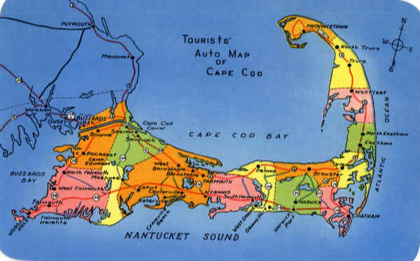
Front:
Ware ham
DOM
MIN
BUZZARDS
BAY
ONS
PLYMOUTH
(20)
almouth
MANOMOF
BUZZARDS
FRIMOUTA
Heights
Bourne
24)
Worth Falmouth
Pocasset
CAMP
Edwards
West Falmouth
SAGMORE
prosess
Mashgee
(30
Cape Cod
CANAL
SANDWICH
O CA
west
Barnstable
Cotur
TOURISTS'
Ostery
Centervilles
lig
CraiGvill
Beach
Auto MAP
OF
CAPE COD
BANStable O
CAPE
YARMOUTH
NYANNIS
RN
COD BAY
DENNIS
South Yarmouth
NANTUCKET SOUND
West DENNIS
Dens Por
Harwich
Port
PROVINCETOWN
North TruPo
Brewster
HARWICH
Truro
Well Fleet
CHATHAM
OCEAN
North Eastham
Eastham
ATLANTIC
E
Back:
SOUTH YARMOUTH, CAPE COD, MASS.
DISTRIBUTED BY E. D. WEST CO.,
35-TOURISTS' AUTO MAP OF CAPE COD
ROUTE 6, MIDCAPE HIGHWAY, Sagamore to
Route 132 11.0.
ROUTE 6A (north shore) Sagamore to Barn-
stable 13.5; to Yarmouth 4.0; to Brewster
10.0; to Orleans 5.5; to Provincetown 28.6.
ROUTE 28 (south shore) Buzzards Bay to Fal-
mouth 16.0; to Hyannis 24.0; to Harwich-
port 12.0; to Chatham 7.0; to Orleans 4.6.
ROUTE 130 crosses the Cape from Sandwich
to Santuit.
ROUTE 132 crosses the Cape from West Barn-
stable to Hyannis.
ROUTE 134 crosses the Cape from East Dennis
to West Dennis.
ROUTE 137 crosses the Cape from Brewster
to So. Chatham.
ROUTE 24 crosses the Cape from Brewster to
West Harwich.
ROUTE 39 crosses the Cape from Harwich
to So. Orleans.
Genuine Curteich-Chicago "C. T. Photochrom" Post Card (Reg. U.S. Pat. Off.)
M. Tulle
1965
IC-P1661


