Front:
CITCAGO
SAN FERNANDO
VALLEY
ARROWHEAD
MONROVIA
GLENDORA
PASADENA
AZUSA
HIGHLAND
ORA NGE
SAN
BERNARDIND
CUCAMONGA
RIALTO
CLAREMONT
Hollywood
UPLAND
ETIWANDA
COLTON
MENTONE
REDLAND
LOS
ANGELES
HIGHGROVE
Santa 1Monica
Ocea Park
Venice
GROVES
WHITTIER
RIVERSIDE
LOS NIETOS
LA MIRADA
ARLINGTON
RICHFIELD
Wennatmas
FULLERTON
CORONA
PLACENTIA
Redondo
ANAHEIM
ORANGE
Perris
Santa Aña
LongBeach
San Pedro Naples
TO SAN DIEGO
Pt Pencig
RELEIF MAP OF
Cake Ei
SOUTHERN CALIFORNIA
SHOWING
Huntington Beach
Newport Beach
Balboa Beach
KITE SHAPED TRACK
Scale of Mles.
MODELED 8Y &R.PRINCE. les AncaLes.CM.
Krtical Scale je0'"
Cappright 1908 By Atchisen Tapeka & Santa Fe Railway Compeny.
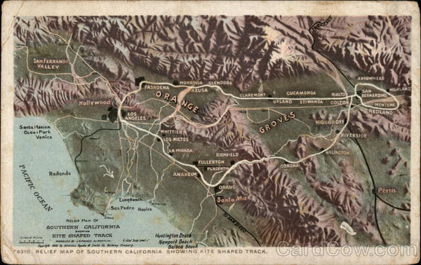
79310 RELIEF MAP OF SOUTHERN CALIFORNIA. SHOWING KITE SHAPED TRACK.
РАСТFIC ОСЕAN
Back:
PLACE STAN
Free
ARVEY
IRED
UNITED STATE.
AND CANADA.
FOREIGN. TWO
MADE ONLY BY DETROIT PUBLISHING CO.
"PHOSTINT" CARD.
TRADE MARK - REG U.S. PAT. OFF.
The Kite Shaped Track is 158 miles
long, and, being shaped like a figure 8,
there is no scene twice seen. It is a day's
journey through the sunny San Gabriel
Valley with its orange groves and flowers
growing in the very shadow of snow-
crested mountains, through the interesting
cities of Redlands and Riverside and past
the famous Arrowhead. Every mile of the
way presents new and beautiful scenery.
THIS SPACE MAY BE USED FOR MESSAGE.


