Front:
SEATTLE
PORTLAND TACOMA
PORTLANSEA
PORTOLA
WINNEMUCCA
OROVILLE
MARYSVILLE
STOCKTON SACRAMENTO
OAKLAND
LOS ANGELES
SAN DIEGO
BUTTE
OGDEN
BINGHAM
HELENA
YELLOWSTONE
PARK
MONTESSERA
PROVO
LT LAKE CITY
GRAND JUNCTION
DURANGO
SANTA FE
SALIDA
GLENWOOD SPRINGS
LEADVILLE
EL PASO
0183 UGAR CITY
DENVER
COLORADO SPRINGS
DERVER & MIC CHANDE
MEXICO CITY
@coca
SAN ANTONIO
LAREDO
NCOLN
OMAHA
CENIC
ST. JOSEPH
TOPEKA KANSAS CITY
LITTLE ROCK
ET WORTHDALLAS
HOT SPRINGS
HOUSTON
JEFFERSON CITY
ST. LOUIS
MEMPHIS
GALVESTON
NEW ORLEANS
ARI
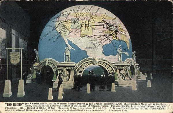
See America Iron Mountain & Southern
"THE GLOBE"tes, located in the northwest corner of the Palace of Transportation, Panama-Pacific International Exposition, San
Francisco, 1915.
Height of Globe, 44 feet; diameter, 51 feet; extension, 50 x 50 feet.
where illustrated literature and information on any desired district may be obtained. Admission Free.
A Bureau is maintained within "The Globe,
Back:
So
"THE GLOBE" In the PALACE OF TRANSPORTATION, Panama-
Pacific International
Exposition, San Francisco.
On the outside is a map of North America, the largest spherical
map in the world, showing the territory served by the lines of the
Western Pacific-Denver & Rio Grande-Missouri Pacific-St. Louis,
Iron Mountain & Southern. Within is displayed a series of twenty-
four illuminated models of cities and towns, mining camps, agricul-
tural districts, industries and notable scenic points located on the
lines of the railroads named.
and Canada,
Foreign,
Two Cents
