Front:
105
30
LONDON
TO KREMANTLE V
ZOCON BOTTO
Talou
105
TRE ASHAANLEIDSONG
A CANYON
110
AUSTRALIA
FREMANTLE
PERTH
DARWIN
120
NORTHERN
TERRITORY
SOUTH
AUSTRALIA
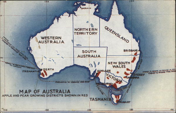
MAP OF AUSTRALIA
APPLE AND PEAR GROWING DISTRICTS SHOWN IN RED
FREMANYLE TO ABBLATTE FRIS ROLE
do
135
QUEENSLAND
ADELAIDE
MILES
NEW SOUTH
WALES
ELBOURNEO
130
VICTORIS
TASMANIA
BRISBANE
ANDERRA
THOBART
150
SYDNEY
**** YA
***** 12:380
SYONEY TO MANARA YA NEG
avewy
Back:
THE CONTINENT OF AUSTRALIA
APPLE, PEAR AND GRAPE GROWING AREAS
The apple, pear and grape growing areas of Australia are coloured red
on the map. In the east they extend from southern Queensland through New
South Wales to Victoria, Tasmania and South Australia. In the west, apples,
pears and grapes grow in the temperate south-west of Western Australia. In
the sub-tropical districts (give latitude for children to find on map) the fruit-
growing sections concerned are located at altitudes that offset the latitude.
In every state of Australia there are conditions of soil, rainfall and climate well
suited for the successful growth of apples, pears and grapes of fine quality, delicious
flavour and high nutritive value.
EXPORTS TO GREAT BRITAIN
In 1937 quantities of apples and pears exported to Gt. Britain were
approximately :
State of Origin
Tasmania
Victoria
Western Australia
South Australia
New South Wales
Queensland ...
...
...
Apples.
(40 lb. boxes)
2,447,000
646,000
433,000
222,000
78,000
14,000
3,840,000
...
:\
Pears.
(40 lb. boxes)
213,000
477,000
23,000
50,000
14,000
Totals for Commonwealth
777,000
In addition, Australia sent to the United Kingdom 1,140 centals of grapes.
(A cental is 100 lbs.)


